Montreal sits atop a complex Paleozoic sedimentary sequence—Trenton limestone, Utica shale, and Chazy dolostone—blanketed by Champlain Sea clays, glacial till, and occasional sand lenses that can exceed 40 meters in thickness east of the metropolitan core. Getting a reliable depth-to-bedrock map in this setting is rarely straightforward with drilling alone; the contact between stiff till and weathered shale often fools conventional refusal counts. Seismic tomography resolves this ambiguity by imaging velocity contrasts directly, delivering a continuous cross-section rather than a column of scattered point data. For projects within the Montreal census metropolitan area, we tie acquisition parameters to the NBCC 2020 site classification framework—Vs30 is just the start when you need to know whether that “bedrock” is competent limestone or fractured shale with a 20-meter transition zone. The method also helps identify buried paleochannels that can redirect groundwater toward deep excavations in Ville-Marie or Griffintown.
Refusal in till is not bedrock—seismic tomography shows the velocity gradient, and the reflection stack finds the real impedance contrast beneath it.
Service characteristics in Montreal
Critical ground factors in Montreal
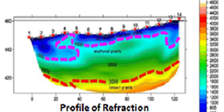
We frequently see projects in Montreal where the geotechnical report assigns a Site Class C or D based on a single Vs30 measurement, yet the shear-wave velocity profile from seismic tomography reveals a velocity inversion—a stiff crust over softer clay—that changes the site period significantly. This matters enormously for mid-rise structures in Hochelaga-Maisonneuve or Rosemont where the fundamental period of the building can align with the site period computed from the full velocity model. Another recurring issue is mistaking a boulder line within the till for bedrock; refraction tomography alone can be ambiguous here, but a coincident reflection survey identifies the continuous reflector below the boulders. Ignoring these details leads to either over-excavation costs or under-designed seismic demands. The Champlain Sea clay also exhibits a pronounced weathering crust that can artificially raise apparent velocities in the top 3–5 meters, and only an inversion that accounts for vertical velocity gradients will correct for this bias in the Vs30 calculation.
Our services
Our Montreal work covers the full seismic tomography workflow—from survey design through final velocity models integrated with the geotechnical baseline report. The three core service packages are described below.
Refraction tomography for bedrock mapping
Designed for depth-to-bedrock determination and rippability assessment. We use arrays up to 120 meters in length with 24–48 channels, processing first arrivals through non-linear inversion to resolve lateral velocity gradients typical of the Montreal till-over-shale sequence. Deliverables include 2D velocity sections and a bedrock surface contour map referenced to site coordinates.
High-resolution reflection profiling
Applied when refraction methods cannot penetrate a high-velocity cap or when sub-bedrock structure matters—faults, karst cavities in the Beekmantown dolostone, or fracture zones in the Utica shale. We deploy a hammer or weight-drop source with a 48–72 channel spread and process the data through pre-stack depth migration to produce a true-depth section with sub-meter vertical resolution.
Combined refraction + reflection with Vs30 profiling
The standard package for NBCC site classification. We acquire both P-wave refraction and S-wave refraction (using horizontal geophones and a shear source), then invert for Vs30. The reflection component adds a bedrock confirmation reflector. The package includes a formatted site-class letter suitable for the structural engineer of record.
Frequently asked questions
What depth of investigation can seismic tomography reach in Montreal's glacial deposits?
Refraction tomography typically reaches 50–100 meters with a 120-meter spread and a weight-drop source; reflection profiling can image to 300 meters or more. The practical limit depends on the velocity contrast at the target interface and the attenuating effect of the Champlain Sea clay, which tends to absorb high frequencies above 80 Hz.
Can seismic tomography distinguish between dense till and weathered bedrock?
Yes, and that is precisely where the method adds the most value in Montreal. Refraction tomography shows the velocity gradient within the till—typically 1,400–2,100 m/s—while the reflection stack picks the sharp impedance contrast at the till-bedrock interface, which appears as a distinct reflector at depth. The combination removes the ambiguity that plagues refusal-based borehole logs.
How much does a seismic tomography survey cost in Montreal?
For a combined refraction and reflection survey in the Montreal area, budgets generally range from CA$3,650 to CA$6,350 depending on the line length, number of spreads, source type, and whether Vs30 profiling is included. A site-specific quote is prepared after reviewing the project location and target depth requirements.
What surface conditions limit seismic tomography in Montreal?
Asphalt and concrete surfaces couple well with geophones using plaster or wax; loose gravel or snow cover requires burial of the sensors. The main limitation in Montreal's dense urban neighborhoods is ambient noise from traffic and LRT lines—we mitigate this with vertical stacking and by scheduling acquisition during low-noise windows, typically early morning or late evening. More info.