A mid-rise residential project in Rosemont–La Petite-Patrie ran into a snag when the preliminary borehole log suggested a stiff till but the dynamic response didn’t align with the structural model. The architect called us mid-foundation design, and within two days we had a 24-channel landstreamer spread across the site, mapping a sharp velocity inversion that the driller had barely nicked. That’s the reality of Montreal’s subsurface: the glacial till overlying Champlain Sea sediments creates a layered velocity profile that a single borehole or SPT log can misread, and the NBCC 2020 seismic hazard values for eastern Canada don’t forgive a site class mistake. When the bedrock depth jumps from 8 m to 25 m across a single lot—common in the Sud-Ouest and along the escarpment—the only practical way to pin down the seismic site classification is a surface-wave survey that captures the full shear-wave velocity column without interpolation between boreholes.
The NBCC Vs30 boundary between Site Class C and D sits at 360 m/s—a 15 m/s shift can change the design base shear by 25% in Montreal’s seismic context.
Service characteristics in Montreal
Demonstration video
Critical ground factors in Montreal
The NBCC 2020 assigns Montreal a relatively moderate seismic hazard on the national scale, but the amplification potential of the Champlain Sea clays—which can reach 40–60 m in thickness across the central and eastern parts of the island—changes the risk profile dramatically. A Site Class E assignment (Vs30 below 180 m/s) on a deep clay basin can amplify short-period spectral accelerations by a factor of two or more compared to a Class C reference condition, directly increasing the seismic design forces on the lateral system. We’ve seen this play out on the east end of the island near Pointe-aux-Trembles, where the bedrock drops below 50 m: the Vs30 measured 155 m/s, pushing the structure into a higher seismic force category that the original borehole-only investigation had missed by assuming a stiffer profile based on SPT blow counts alone. The geotechnical team had to retrofit the foundation design, adding shear walls and denser reinforcement—a costly correction that a pre-design MASW survey would have flagged from the start. For essential facilities governed by the NBCC importance factor, the site class drives not just the base shear but the foundation type and the allowable bearing pressure under seismic load combinations.
Our services
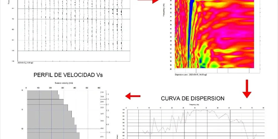
Every Montreal MASW survey we deliver includes the raw field records, the dispersion image, the inverted Vs profile, and a formal Vs30 calculation with the NBCC site class designation—because a single number without the underlying data doesn’t hold up in a peer review. The services below cover the range of project scales we encounter, from individual lot investigations to corridor-length profiling.
Active-Source MASW Survey
24-channel linear spread with sledgehammer source, processed to a 1D Vs profile and Vs30. Suitable for sites with bedrock within 30 m and clear line-of-sight. Includes dispersion curve quality control and multi-mode inversion where higher modes are present.
Combined Active-Passive MASW
Adds ambient microtremor recording with circular or L-shaped arrays to extend depth of investigation beyond 60 m. Recommended for deep Champlain Sea clay basins on the east island and St. Lawrence lowlands where bedrock may exceed 50 m depth.
Vs30 Site Classification & NBCC Compliance Report
Formal site class determination per NBCC Table 4.1.8.4.A, with Vs30 calculation, travel-time averaging, and commentary on spectral acceleration implications. Sealed by a professional engineer registered in Quebec.
Frequently asked questions
What does a MASW survey in the Montreal area typically cost?
For a standard active-source MASW survey on a single lot in the Montreal region, the cost generally falls between CA$2,300 and CA$4,550, depending on the array length, the number of measurement locations, and whether passive microtremor recording is required to reach deeper bedrock. Sites with difficult access, steep terrain along the escarpment, or frozen ground in winter may require additional mobilization time, which influences the final price.
How does the Champlain Sea clay affect the Vs30 measurement?
The Champlain Sea clays that underlie much of central and eastern Montreal are normally consolidated to lightly overconsolidated silts and clays with shear-wave velocities typically in the 90 to 180 m/s range. This places many sites in the NBCC Site Class D or E boundary zone, where the Vs30 value becomes critical for seismic design. The MASW method is particularly effective in these soft-soil conditions because Rayleigh-wave dispersion is sensitive to the low-velocity layer, and the inversion can resolve the velocity contrast between the clay and the underlying till or bedrock.
Can the MASW survey be performed in winter when the ground is frozen?
Yes, but the frozen surface layer must be accounted for in the processing. A high-velocity frozen crust (typically 0.8 to 1.8 m thick in Montreal) introduces a strong velocity gradient that can mask the underlying soil profile in the active-source dispersion curve. We address this by incorporating passive microtremor data that samples below the frost line, and by modelling the frozen layer explicitly in the inversion. The result is a Vs30 that reflects the unfrozen soil condition governing the seismic site response, not the temporary winter crust.